Exploring the East-West Cultural Corridor: Historic and Modern Archaeology of Bago and Dawei, Myanmar
Elizabeth Howard Moore
Former Visiting Researcher CSEAS
The East-West Cultural Corridor and the Southern Coastal Zone
The East-West Corridor is a conceptual tool for identifying common cultural processes across mainland Southeast (Ishii 2009). Our research group has drawn upon this model to study the past histories of sites and their continuities with present traditions. My role in our group has been adding Myanmar to our database of Thailand, Cambodia, Vietnam and Laos and widening our discussion of the East-West Cultural Corridor concept. Our ‘sites’ vary in size, at times end-points, and at others, connectors along routes that over many centuries have connected Myanmar to capitals such as Sukhothai (13th–14th), Ayutthaya (14th–18th) and Angkor (9th–15th) (Shibayama 2013).1 The ‘routes’ include walls, moats, streams, paths and special purpose roads used by man, ox-carts and elephants to move within, between, and beyond sites (Im Sokrithy 1998, 101; Surat Lertlum and Im Sokrithy 2013).
We follow Ishii’s example in using ecological zones rather than dynastic lines to divide Myanmar into three regions as our primary framework:
1.Upper Myanmar: the broad Ayeyarwaddy (Irrawaddy) basin (c. 650–1250 mm rainfall per annum)
2. Lower Myanmar: the plains bordering the Gulf of Muttama (Martaban) (c. 5000 mm)
3.The Southern Coastal Zone: the 600 km long peninsula (c. 5000 mm) with river valleys sandwiched between the Andaman Sea and the 700 m high Tanintharyi (Tennasserim) Range
While we have identified links between sites in Upper Myanmar, Yunnan and south to Thailand, our focus is Lower Myanmar and the Southern Coastal Zone, two regions of vital significance whose early and later archaeology has been little studied. Two sites are compared here, Bago (Pegu)2 in Lower Myanmar and Dawei (Tavoy) 3 in the Southern Coastal Zone. Each is the western terminus of routes east: Bago leads to Haripunchai, Sukhothai and Chiang Mai in Northern Thailand and Dawei via multiple passes over the mountains to Kanchanaburi and Ayutthaya.4
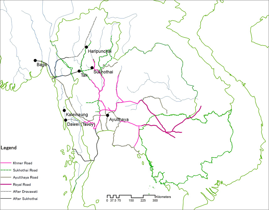
Fig. 1: Map showing Bago, Dawei and sites in Thailand. Courtesy of Mamoru Shibayama
In the historical sketches below, a 9th century traditional founding is followed by a millennium of conquest by greater powers: at Bago to establish a new capital and at Dawei to lay claim to the seaward side of the Tanintharyi peninsula. The process internationalized Bago but in Dawei, apart from a few stupas said to be ‘Thai-style,’ the isolation and conquest as a region rather than a center, encouraged an insular pride with a strengthening of local modes and styles. The historical sketches end with World War II images from the Williams-Hunt Collection as comparison of these with present day images can help us contrast the rapid expansion of Bago and the relatively stable Dawei landscape.5
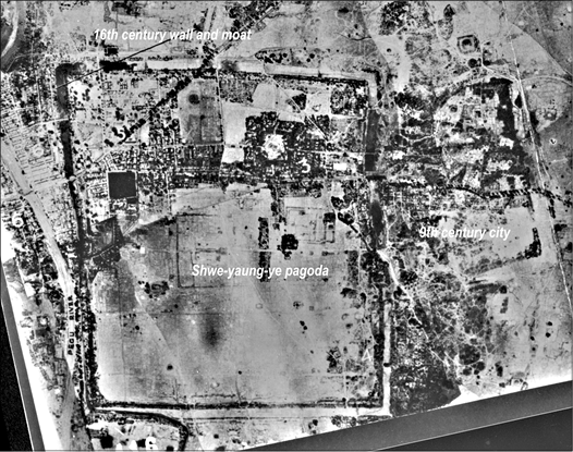
Fig. 2: Bago in 1942, Williams-Hunt Collection, Geo-referenced courtesy Surat Lertlum, CRMA
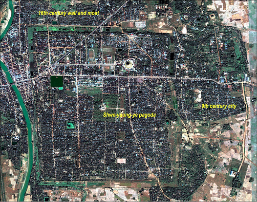
Fig. 3: Bago in 2002, IKONOS, Geo-referenced courtesy Surat Lertlum, CRMA
Bago: 9th to 16th Century Capital
The chronicle history of Bago (Ussā-Hanthawaddy) dates the original rectangular walled site (120 ha) to 825 (Moore and San Win 2014). In the 11th century, Bago was dominated by the Upper Myanmar capital at Bagan6 but in the 14th century it ended up being ruled by a succession of eleven Mon kings from nearby Martaban (Muttama) (Tun Aung Chain 1999: 38). Among these was Dhammaceti (1470–1492), whose reign, free from invasion from the Upper Myanmar capital at Ava (Inwa)7 brought expanded trade. Gifts sent by on a religious mission to Sri Lanka in 1476 included cloth from China, betel boxes from Haripunchai and carpets from Inwa – all indicative of a trade network stretching from the Gulf of Martaban (Muttama) to Yunnan. Bago reached its peak in the 16th century under a line of rulers from the Upper Myanmar capital of Toungoo8 with its geographical position giving it maritime access to goods from South Asia and the river valleys on its landward side that linked it to inland trade (Tun Aung Chain 1999, 42, 37). It was at this time that a vast new moat and wall (571 ha) were built by King Bayinnaung (1552–1581) lying just southeast of the original site. As noted by Ralph Fitch in 1586;
‘It is a Citie very great and populous, and is made square with very Faire walls and a Ditch round it full of water with many Crocodiles in it…there are also Turrets for Centinels to watch, made of wood, and gilded with Gold very faire’ (Fitch 2004, 170).
The 16th century rulers brought artisans from Ayutthaya, conquered in 1548, including goldsmiths, painters, cooks and cloth dyers. Trade from the interior to the port was encouraged, so that Bago was active in 16th century European and Japanese markets (Tun Aung Chain 1999: 43). In the 17th century, however, the ruling dynasty moved the capital back to Upper Myanmar and the land base of Bago dwindled while deposits of alluvium narrowed the Bago River and destroyed its access to the sea.
In 1757, much of Lower Myanmar was devastated by Upper Myanmar rule, Alaungpaya and in 1852, the British took control of Lower Myanmar. With World War II, British troops took extensive cover of Bago including a mosaic of the ancient city on 20 March, 1942, two months after the Japanese took Dawei. The outline of the 16th century wall and moat is strikingly clear, as is the absence of a dense population apart from the northwest corner of the site adjacent to the Bago River. Lines of rectangular vegetation are the only remnants of the once-renowned palace and the lively 16th century capital described above.
Dawei and the Southern Coastal Zone
Dawei’s chronicle history begins in 707 at Kaleinaung, 60 km north, and its royal lineage in 754 with the walled site of Thagara (176 ha).9 As with Bago, Dawei’s location attracted conquest by a succession of more dominant powers: not only Upper Myanmar, but Lower Myanmar and Thailand. The latter included a 10th century line of Thai princes from Tak and Ayutthaya rule from 1350. Thai links are seen also at Mokti (c. 150 ha), a walled site 9.6 km south of Dawei dated to 1417. A bronze bell was donated to Mokti in 1432 by Wikara Orada, a Thai person of high status.10
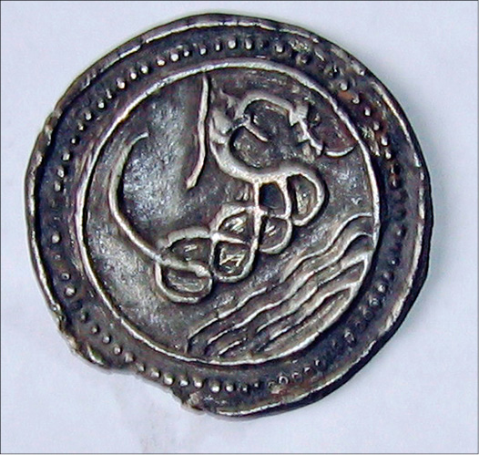
Fig. 4: Lead coin (10 cm), Collection Than Swe (Dawei)
During the 16th and 17th centuries, Dawei rule moved between Upper Myanmar and Ayutthaya including a successful attack in 1593 by King Nareusuan. The 1757 present walled city was soon seized by Upper Myanmar with Tanintharyi (Tennaserim) ranked as a second level city within four levels by the Ayutthaya monarch in the 1805 edited ‘Law of the Three Seals’ (Kotmai Tra Sam Duang) (Ishii 1998). In 1826, Lower Myanmar and Tanintharyi Division were ceded to the British who were quick to document routes to Thailand and demarcate the border. An 1826 map of Dawei, for example, includes Kaleinaung of the Dawei chronicle, the starting point from which the Dawei River is navigable, and a route to Thailand. Kaleinaung is also marked on a 19th century Siamese royal military map and a 1917 geological survey (Hearn 1917, Pasuk Santanee 2004). By the early 20th century, the British administrative documents focused on the isolation of the region, documenting routes east to the disputed border and Siamese elephant stealing (NAD 1919).
Dawei was invaded on 18 January, 1942, with the battle being the first clash between British and Japanese troops inside Myanmar. The Williams-Hunt Collection photographs of Dawei include the elaborate Japanese expansion of airport runways taken in December 1944 during the British campaign to re-take the country (Defence Surveyors Association: 216, 237).
Conclusion
This article has shown how, in the 16th century, Bago was internationally renowned as a port linking South Asia to the interior of the mainland overland. Its power waned after the silting up of the Bago River and Upper Myanmar rulers returned the capital to the north. The Department of Archaeology excavated Kambawzathadi Palace in the 1990s, included it in the 1996 UNESCO World Heritage Tentative List11 and in 1999 inscribed it on the Ministry of Culture’s Notified Zones of Cultural Heritage Regions and Buildings. Today, however, the moats are thick with vegetation and refuse on the eastern side at the Shwe-yaung-ye pagoda where the massive 16th century wall curves around this stupa, a clear note of the ancient respect for its earlier construction (Pyiet Phyo Kyaw 2013).
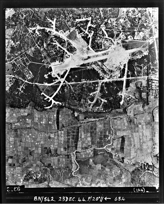
Fig. 5: Dawei airport in 1944, Williams-Hunt Collection
The famed beauty of its wide streets and gilded turrets can be glimpsed in the reconstructed palace buildings, still-venerated pagodas, and the vibrancy of its ceramic artefacts. However, the population of over 300,000 in the immediate metropolitan zone has obscured the ancient cultural landscape, a process that will accelerate with the completion of the Hanthawaddy International Airport in 2017.12 This comparison is particularly vivid in a geo-referenced comparison of a 1942 aerial photograph of Bago from the Williams-Hunt Collection and an IKONOS satellite image of the site (Lertlum and Shibayama 2009, 549).
In contrast to the fame of Bago, Dawei was a medium-size port and territorial prize traded between kings of Upper Myanmar, Thailand and from 1824, under British rule. Local styles can be seen in 7th to 9th century images of the Buddha to 15th–18th century brown and green glazed wares and large (10 cm diameter) lead and tin coins. The Dawei dialect, a variant of the Myanmar language, has survived in orally transmitted folk songs (Winn Myintzu 2011). The ecology, again in contrast to Bago, has remained constant, with major change only with the expansion of tin and lead mining in the colonial era. In addition, rather than being a single massive walled site as seen at Bago, Dawei was a series of smaller fluctuating sites north and south of the 1754 town of present Dawei.
Unfortunately, the area has not been without cultural destruction, as in the long period of insurgent activity following 1948 independence, the walled site of Weidi (114 ha) became an insurgent camp and its rich supply of large lead coins dating to the 15–17th century were melted down for bullets. For the most part, however, the ancient sites of Dawei are intact. The region is in the process of change, and has come to international attention with the development of a large deep-sea port project, but this has catalyzed local attention, with the 2012 inscription of Thagara (Thargaya) on the Ministry of Culture’s list of Notified Cultural Zones, the first site from the entire Tanintharyi Division.
At Bago and Dawei, the archaeological remains of the first millennium data provide the foundation from which to compare later cities. Conversely, the networks identified in the historical period provide a template through which to explore the earlier communication systems. There has been little attempt to weave synchronic site studies such as these into a wider frame that gives credibility to both continuities into the past and into the present (Aung-Thwin 2013, 97). It is hoped that this study may contribute to our appreciation of this duality.
References
Aung-Thwin, Michael. 2013. Continuing, re-emerging, and emerging trends in the field of Southeast Asian history. TRaNS: Trans Regional and National Studies of Southeast Asia, 1: 87-104.
Defence Surveyors Association, N.D. Maps and surveys, Chapter VIII. Southeast Asia. http://www.defencesurveyors.org.uk/world-war-2/item/211-maps-and-survey-contents.html (accessed 18 August, 2013).
Fitch, Ralph. 2004. An account of Pegu in 1586-1587. SOAS Bulletin of Burma Research, Vol. 2, No. 2: 167-179.
Hearn. A.W. 1917. Notes on Zinba Chaung Route from Tavoy to Siam. A/C NAD 97, Vii-123a. National Archives of Myanmar, Ministry of National Planning and Economic Development.
Im Sokrithy. 1998. Réseaux routiers et moyens de transport à l’époque angkorienne sde l’IXème aux XIVème siècles [Road and transportation networks: Angkor 9th to 14th century]. Unpublished MA Thesis, École des Hautes Études en Sciences Sociales.
Ishii, Yoneo. 1998. Tai Kinseishikenkyu Jyosetsu [Introduction to Thai early modern history] Tokyo: Iwanami Shoten.
Ishii, Yoneo. 2009. Sukhothai wo Tsuka Suru ‘Tozai Kairo’ ni Kansuru Oboegaki [A note on the East-west corridor passing through Sukhothai]. Tonan Asia: Rekishito Bunka [Southeast Asia: History and Culture], 38: 5-12.
Lertlum, Surat and Im Sokrithy. 2013. The Living Angkor Road Project (LARP): A Cross-border Archaeological Research Project. Paper presented at the 1st SEAMEO SPAFA International Conference on Southeast Asian Archaeology, 7-10 May 2013, Burapha University, Chonburi, Thailand.
Lertlum, Surat and Shibayama, Mamoru. 2009. Application of Geo-informatics to the Study of the Royal Road from Angkor to Phimai.Southeast Asian Studies, 46(4): 547-563.
Moore, Elizabeth Howard and San Win. 2014 (forthcoming). Sampanago: ‘City of Serpents’ and the First Muttama (Martaban) in Before Siam was Born: New Insights on the Art and Archaeology of Pre-Modern Thailand and its Neighbouring Regions, edited by Nicolas Revire and Stephen Murphy. Bangkok: River Books.
National Archives of Myanmar. 1919. Meeting between the British and Siamese officials at Baumti (Ac Accession 104, no 94-107 reel 7). Ministry of National Planning and Economic Development.
Phasuk, Santanee. 2004. Royal Siamese Maps: War and Trade in Nineteenth century Thailand. Bangkok, River Books.
Pyiet Phyo Kyaw. 2013. Bago Hamsavadi Ancient City Walls and Moats. Presentation, Department of Archaeology, Yangon University.
Shibayama, Mamoru. 2013. An Examination of the East-west Cultural Corridor. Paper presented at the 1st SEAMEO SPAFA International Conference on Southeast Asian Archaeology, 7–10 May, 2013, Burapha University, Chonburi, Thailand.
Snodgrass, John. 1827. Narrative of the Burmese War. London: John Murray.
Tun Aung Chain. 1999. Pegu in Politics and Trade, Ninth to Seventeenth Century. In Recalling Local Pasts: Autonomous History in Southeast Asia, edited by Sunait Chutintaranond and Chris Baker, pp. 25-52.
Notes
1 Mamoru Shibayama (Kyoto), Surat Lertlum (Chulachomklao Royal Military Academy), Pongdhan Sampaongern (Fine Arts Department, Thailand), Surapol Natapintu (Thailand Research Fund), Im Sokrithy (APSARA, Cambodia), Tran Ky Phuong (Danang, Vietnam)
2 Bago 17°17’58.38 “N, 96°28’59.81”E; Sukhothai 16.951169°N, 99.855425°E; Ayutthaya 14°21’11.65”N, 100°34’8.28”E; Angkor 13°25’55.42”N, 103°52’18.72”E
3 Dawei 14°10’23.99”N, 98°10’0.58”E
4 Haripunchai 18.577107°N, 99.006826°E; Kanchanabui (13.996865°N, 99.555616°E) via Pilok (14.681037°N, 98.362935°N), Sangklaburi (15°16’25.74”N, 98°17’52.30”E), and the Amya Pass (13.888381°N, 99.075318°)
5 The Williams-Hunt Collection is an archive of 5000+ 1942-1955 aerial photographs of Cambodia, Thailand, Myanmar, Singapore and Vietnam. The online siteis a collaboration between Mamoru Shibyama and Yasuyuki Kono (Kyoto), Surat Lertlum (CRMA) and Elizabeth Howard Moore (SOAS). See http://gdap.crma.ac.th
6 Bagan 21.124613°N, 94.922275°E
7 Inwa 21.856932°N, 95.981813°E
8 Toungoo 18.933333°N, 96.433333°E
9 Kaleinaung 14°37’28.95”N, 98°08’13.79”E; Thagara 14°10’22.91”N, 98° 9’57.85”E
10 The bell inscription includes the words kara (king) and orada (a royal rank) (Surapol Natapintu, pers.comm. 22.12.12)
11 1996 UNESCO World Heritage Tentative List. http://whc.unesco.org/en/tentativelists/ (accessed 13 Aug, 2013)
12 In 2012, 284,179 with 5,739,344 in the metropolitan area; See Myanmar to Build largest airport. http://www.mizzima.com/business/investment/9843-myanmar-to-build-largest-international-airport (accessed 14 Aug, 2013)
