Term:2014-2015
Outline of Research:
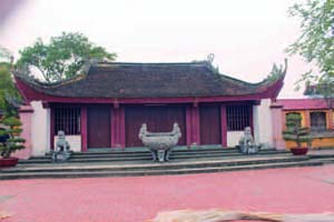
Communal hall of Giới Tế village (Tiên Du district, Bắc Ninh province)
Present studies of 17th–19th centuries Vietnamese village communities utilizing local historical materials give us important findings. However, these are not enough to connect the regional histories of agricultural development. At present, I am examining some villages in Central and Northern Vietnam through local historical materials. This study examines regional agricultural development around a researched village by collating the maps and satellite photographs owned by the Center for Southeast Asian Studies with the geographical information from 19th century cadaster and the geographical information from field research. The results in the examination of transition of he 17th-18th centuries village community will be used to purpose connecting the history of village communes with the history of regional agricutural development.
Description:
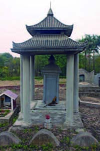
Existing inscription of the last 17th century at the site of the Shrine of Trương Viết Quý (in Giới Tế village)
Concerning the history of agricultural development in the Red River Basin, Sakurai Yumio found embankments of unenclosed horse hoofshaped dyke networks in the Tran dynasty, and Nishimura Masanari, from the viewpoint of archaeology, pointed out the possibility that these shifted to enclosed-type dykes in the 17th-18th centuries. Nishimura insisted that this transition caused various social transitions, for instance, population growth, agricultural development, and the rise of the riverbed. However, as he himself indicated, there has not been a more rigourous historical examination. On the other hand, at present, historical approaches toward village communities are developing rapidly through the spread of the analysis of village documents. At the same time these studies are not
enough to connect with the macro history of agricultural development because village community studies share a common fault, which is, there are not simply enough at present.
In this study, I analyze the history of regional agricultural development by collating the geographical information from field research and 19th century cadaster with geographical information from documents such as maps and satellite photographs which the Center for Southeast Asian Studies has in its possession. After that, I will uncover the establishment and transition of each village to link their history of regional agricultural development. This work is needed to connect a minimum number of case studies of village communities with a study of macro agricultural development in the Red River Basin. At present, I am researching at Thanh Ph˝ớc village (H˝ıng Trà district, Thừa Thiên-Huế province), Phụng Châu village (Ch˝ıng Mỹ district, former Hà Tây province), Giới Tế village (Tiên Du district, Bắc Ninh province) to collect old geographical information and local historical materials. I will put the geographical sources of
the Center for Southeast Asian Studies to use in my examination with the purpose of uncovering social transition in 17th-19th centuries.