Project Leader:HAYASHI, Kengo (Research Department, Research Institute for Humanity and Nature)
Collaborators:MURAMATSU, Shin (Research Department, Research Institute for Humanity and Nature)
MIZUNO, Kosuke(Center for Southeast Asian Studies, Kyoto University)
MIMURA, Yutaka (Research Department, Research Institute for Humanity and Nature)
Term:2012-2013
Outline of Research:
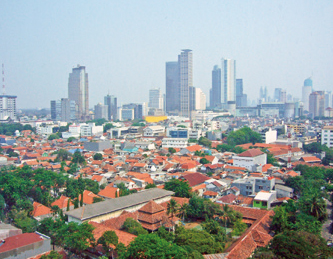
A city skyline of Jakarta
This study aims to clarify the spatial structure of the built environment in Jabodetabek, Indonesia. Firstly it will collect the land use data at the greater metropolitan area level and define the spatial distribution by function, such as residential zone, commercial zone, etc. Secondly, for residential areas, it will classify them into several types, based on physical characteristics, and generate spatial distributions for
each. It will also examine the processes of urbanization for each residential type one by one. By doing this, this research will consider the course of future urbanization.
I will advance my research by conducting short-term field survey several times with co-researchers and staying at CEAS’s Jakarta residence for 3 months in fiscal year 2013.
Study Objective
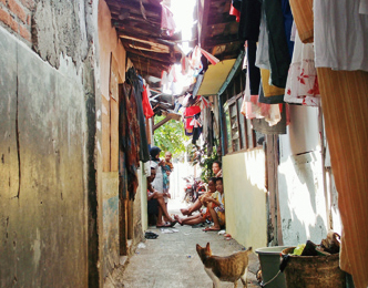
A high-density kampung area
In this study, using the subject of the Jakarta greater metropolitan area (Jabodetabek), a mega-city with the greatest population concentration in Southeast Asia, I aim to clarify the spatial structure of the built environment such as infrastructure, residences and commercial facilities. In particular, I will analyze how the population, which has rapidly increased since independence until present, became established in the city, through focusing on the environmental changes to their residences.
Specifically I aim to do the following: 1) Carry out collection and generation of land use data at the Jakarta greater metropolitan area level, and define the spatial distribution of the building environments separately by function, such as residence, commercial facility, factory, etc. 2) For residential areas, classify them into several types of residential areas, based on physical characteristics, and generate spatial distribution for each. 3) Examine the processes and lifestyles of urbanization for each individual residential type, and grasp the process by which residential areas were formed following independence.
There are several megacities in Southeast Asia with populations exceeding 10 million and the population is expected to further increase in the next few decades. No matter which city it is, the accumulation of man-made objects is striking, and the development of emergent residential districts that target the middle class and upper class is in the process of changing traditional residential environments on a grand scale. However, from the point of view of a sustainable city, a design for the city that makes the best use of the environment and culture already established is essential. Accordingly, in addition to the classification of existing land use, by analyzing the residential areas of an intricately changing city at a greater resolution than previous, will allow us to not only guess the course of future urbanization, but also contribute to showing the advantages possessed by local built environments and culture, aiming towards the creation of a sustainable city.
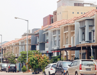
A new residential area expanding in the suburbs