Joint Research (Type I)
Informatization of Area Studies by Cooperative Fieldworks of Information
Scientists and Area Study Researchers
Project Leader: ISHIKAWA, Masatoshi, Faculty of Business Administration,
Tokyo Seitoku University
(Term:2010 - 2011)
- Joint Seminars in 2010 Fiscal Year
- Outline of Joint Research
-
Members of this project that consist of field-based area study researchers
and information scientists will carry out field surveys in Thailand and
Indonesia to integrate their ideas, skills and knowledge, and to create
a new methodology and software/hardware for field-based area studies. Topics
will deal with what members are interested in, such as land use, health
and livelihood. Each of them will take about a week. Equipments and documents
from the CSEAS Liaison Offices in these countries will be used for survey
activities. After the field surveys, workshops for concluding results obtained
through the surveys will be held at the Liaison Offices.
Dr. Tomita Shinsuke (University of Tokyo) who is a member of this project
will stay at the Bangkok Liaison Office in the first half of FY2011 to
collect data and prepare for the survey.
- Purpose of Joint Research
-
This project aims to present:
(1) Ways of more efficiently using conventional tools such as GPS and GIS
in area studies.
(2) Concepts of hard/software that are suitable for area studies.
(3) Concepts of field data collection systems that have a fieldworker-friendly
interface.
(4) Concepts of three-dimensional (time-space) database systems for area
studies.
(5) Methodologies for sharing/analysis of geographical information with
the database mentioned in (4).
Geographical information technologies that are now rapidly developing have
quite a high potential to be applied to area studies where geographical
data collection through field surveys and analysis of spatial data is commonly
conducted. However, there are many technical problems that prevent the
use of such technologies from being widely disseminating among area study
researchers. For example, it is often too difficult for researchers to
handle the latest geographical information devices in the field because
of their weight, fragility, complicated interfaces and so on. This project
will contribute to both the development of area studies and information
science through in-situ discussions among area study researchers and information
scientists.
- Outline of Result
- In this year, we have developed the following tools to support collecting data in fields by area study researchers. Furthermore we have evaluated these tools by preliminary experiments, and proved that they are useful for supporting fieldworks.
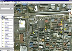
(1) Collected data by devices such as GPS, digital camera and so on cannot be integrated easily because their formats are not unified. So we developed a data integration tool for fieldwork data that can extract data from logs of devices, integrate the data by timestamps and visualize the integrated data using maps. We also evaluated this tool on fieldworks in Bangladesh.
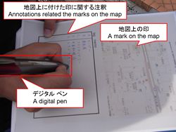
(2) Even now, some researchers use pieces of paper to record data in fields. However recorded data on a piece of paper are difficult to digitize efficiently. So we developed a fieldwork support system that is able to combine recorded data on pieces of paper and to digitize them efficiently using a digital pen. The system can integrate hand-written data, GPS tracing data and digital photos by timestamps, and translate to KML data from the integrated data. We also evaluated the system on fieldworks in Indonesia.
Next year, we plan to implement a database for sharing geographical data collecting tools developed by us and evaluate the database.
▲Top of This Page
|