Joint Research (Type IV)
Comparative Study of Land Uses in Southeast Asia
Project Leader: UMEZAKI, Masahiro, Graduate School of Medicine, University
of Tokyo
(Term:2009 - 2010)
- Joint Seminars in 2009 - 2010 Fiscal Year
- Outline of Joint Research
- Newly-developed remote sensing techniques (i.e., object-based classification
on the basis of GRAPH theory, texture analyses, and simple ways to remove
terrain effects on satellite images) will be investigated for usefulness
in field studies in Southeast Asia. In occasional workshops, project members
will compile longitudinal land use data to clarify the structures of causes
that have triggered land use change in the region. We also plan to organize
fieldwork for a better exchange of ideas and problems.
- Purpose of Joint Research
-
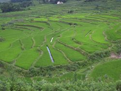
Despite the importance of analyzing spatial patterns of resource uses
in regional studies, they have not been fully studied due to the lack of
methodology suitable for fieldwork. The present study aims at establishing
fieldwork-friendly methodologies of land use/land cover analyses. Object-based
classification (on the basis of GRAPH theory), texture analyses, and simple
ways to remove terrain effects on satellite images will be investigated
for usefulness in the field. By inviting researchers who have long experience
of field work in Southeast Asian countries, land use patterns and their
longitudinal changing patterns will be compiled. The final goal will be
to clarify structures of causes that have triggered land use change in
Southeast Asian countries.
- Outline of Result
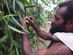
- We conducted fieldworks in Bangladesh during the period between 11 and
18 October, 2010. In the field, we investigated the methodology of spatial
informatics.We used high resolution satellite images for producing base
maps and GPS (global positioning system) and accelerometer for evaluating
individual-behavioral patterns. We also discussed the characteristics and
determinants of land use/cover patterns in Bangladesh referring to their
experiences in various parts of Southeast Asia. During the period between
January and March 2011, we compiled case studies of land use and their
determinants for the future meta-analysis. A workshop will be organized
in 29-30 March 2011 where we concluded the list of fieldworker-friendly
methodologies of land use study.
▲Top of This Page
|