Joint Research (Type IV)
Environmental Change of the Ayeyarwady Delta
Project Leader: HARUYAMA, Shigeko, Graduate School of Bioresources, Mie
University,
(Term:2010 - 2011)
- Joint Seminars in 2010-2011 Fiscal Year
- Outline of Joint Research
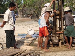
- With enormous water related natural hazards in the lower part of Ayayawady
River Basin, natural environmental change studies of the middle Holocene
should be organized to include advances in fluvial geomorphology. Storm
surges usually createe specific sedimentation in delta morphology.This
project will define the high resolution of deposition process of the delta
area using core drilling. Through human activity such as agricultural development,
land use and land cover has been changing over the watershed of the Ayayawady
river. In the context of agricultural development and urban development
in the river basin, the sedimentation process will be clarified to analyze
the geomorphologic processes of large rivers in Monsoon Asia.
- Purpose of Joint Research
-
There is a significant history of the kingdom of Myanmar and of expanding
human activities, however, field study and research results of the natural
environmental changes of the Ayayawady River Basin have been scarce in
the past decades. In this study, we will try to do specific geological
and physical geographical study to clarify disturbances over the land of
the large river watershed, utilizing the deposition characteristics of
high tides, tsunamis and storm surges and also look at remarkable flooding
in the study area. We will also look at fluvial geomorphology, and conduct
a high- resolution analysis for natural environmental change in the large
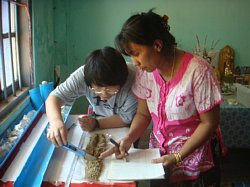
delta area in Monsoon Asia. Geographers from Myanmar will also join the
GIS study for land use and land cover changes of the river basin and will
create scenarios that explain the history of land cover change. In this
study, the historical events of natural disasters will be clarified in
relation to physical and human geographical studies by looking at the the
sequences of environmental change significant in the Monsoon Asia. We will
also look at human and physical geographical theory to analyze the delta’s
progressive Holocene history.
- Outline of Result
- We got the research result as followings; 1) rapid expanding process of
human activities in this area and research result of the natural environmental
change of the Ayayawady River, and 2) land cover change and land use change
process in local area near Yangon. In this study, we tried to do specific
geomorphologic study for clarification of the disturbance over the land
of the large river watershed. Regarding to the fluvial geomorphology and
surface geology, the high- resolution analysis for natural environmental
change in the large delta area in Myanmar was done with specific discussion
of land cover change in historical periods. On the other hand, Myanmar
geographers joined GIS study for analysis of land use change of the river
basin and made the scenario of the history of land cover change. Related
with fluvial geomorphology, the historical events of natural disaster was
cleared on the sequence of the environmental change significant in Ayayawady
delta.
▲Top of This Page
|