Joint Research(Type Ⅳ)
Research on Meteorological Environment and Human Activity in Bangladesh
Project Leader: HAYASHI, Taiichi, Disaster Prevention Research Institute,
Kyoto University
(Term:2011 - 2012)
- Joint Seminars in 2011 Fiscal Year
- Outline of Joint Research
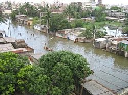
- Meteorological/Climatic phenomena affect the human activity of agricultural
products, the contamination of the atmosphere and water quality. Meteorological
disasters such as cyclones and floods cause damage and contribute as water
resources through precipitation. We will evaluate the quantitative impact
of climatic components to rice products and the prevalence of infectious
diseases.
- Purpose of Joint Research
-
The purpose of this research is to evaluate the quantitative impact of
meteorological and climatological components to human activity. We will
especially focus on the relationship of surface weather variables to the
amount of rice products and the prevalence of infectious diseases. Meteorological
phenomena has yearly , seasonally and daily variations of time scales.
We will find out the preceding key parameter indices and investigate the
possibility of predictions, which may be available to those in other regions
except the tropical region.
- The results of the research will contribute to the reduction infectious
diseases and the increase of rice production in Bangladesh.
- Outline of Result
- Based on the purpose of this research, we carried out the following performances to clarify the relationship between the meteorological environment and the human activity in the south Asia in Bangladesh and India.
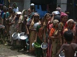
1. Impact of meteorological disasters on the occurrence and prevalence infectious diseases.
2. Impact of the meteorological disasters on the human activities in rural area.
3. Usage of remote sensing data to clarify the spatial distribution of the effect of the above impact.
4. Clarification of various time scale of weather phenomena.
▲Top of This Page
|