Joint Research (Type I)
Informatization of Area Studies by Cooperative Fieldworks of Information
Scientists and Area Study Researchers
Project Leader: ISHIKAWA, Masatoshi, Faculty of Business Administration,
Tokyo Seitoku University
(Term:2010 - 2011)
- Joint Seminars in 2010-2011 Fiscal Year
- Outline of Joint Research
-
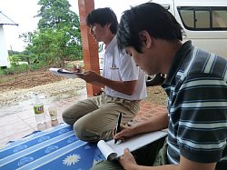
This project aims to develop field survey supporting tools such as digital
field notes and a database for fieldwork. A field survey will be carried
out in Nongkhai Province, Thailand for an in situ evaluation of these tools.
In addition, a workshop for concluding results obtained through the surveys
will be held at the CSEAS Bangkok Liaison Office after the survey. The
field survey will be for one week in August. A member of this study (Dr.
Tomita Shinsuke (University of Tokyo) will stay at the CSEAS Bangkok Liaison
Office to collect data and prepare for the survey during May to August
2011. Equipment and documents at the liaison office also will be used for
the survey and workshop.
Prior to activities in Thailand, a research meeting will be held in Kyoto
or Tokyo in July for testing and modification of the tools.
- Purpose of Joint Research
-
This project aims to present:
(1) More efficient ways of using conventional tools such as GPS and GIS
in area studies.
(2) Hard/software concepts suitable for area studies.
(3) Field data collection system concepts that have a fieldworker-friendly
interface.
(4) Concepts for a three-dimensional (time-space) database system for area
studies.
(5) Methodologies for sharing/analysis of geographical information with
the database mentioned in (4).
Geographical information technologies that are now rapidly de-veloping
have quite a high potential to be applied to Area Studies in which geographical
data collection through fieldsurveys and anal-ysis of spatial data are
commonly conducted. However, there are many technical problems that prevent
the use of such technologies from widely spreading among area study researchers.
For example, it is often too difficultfor researchers to handle the latest
geographi-cal information devices in the fieldbecause of their weight,
fragil-ity, complicated interfaces and so forth. This project will contribute
to both the development of Area Studies and information science through
in-situ discussions among area study researchers and infor-mation scientists.
- Outline of Result
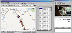
- In this project, we have been developing a field data survey supporting system for area studies since last fiscal year. In this fiscal year, we have evaluated our proposed system by field researchers and improved the system.
Basic functions of the system are an integration function of field data, such as hand written texts recorded by digital pens, GPS position data and digital photos, and a translation function from integrated field data to a KML file or a CSV file for sharing the field data among researchers. In this fiscal year, we have added functions to the system, which are data management functions for each field data, and an integrated data filtering function. By these functions researchers are able to classify, analyze and share the field data collected by researchers on field works efficiently.
Furthermore we have evaluated usability of the system by researchers and graduate students at Kyoto University, Tokyo Seitoku University, and the University of Tokyo. We have also conducted the same evaluation by researchers in Thailand. By the evaluations we found improvement points of the system with respect to user interface and concluded utility of the system.
▲Top of This Page
|