Joint Research(Type Ⅳ)
Integration of Reanalysis Meteorological Data and Village Level Historical
Information about Agricultural Activities in Southeast Asia over the Last
50 years
Project Leader: NAGANO, Takanori, Graduate School of Agriculture, Kobe
University
(Term:2011 - 2012)
- Joint Seminars in 2011 Fiscal Year
- Outline of Joint Research
- The Reanalysis of meteorological data (reanalysis products) that are made
through the assimilation of observed data throughout the world are widely
used in studies on climate change mechanisms. This study aims to analyze
the relations between the reanalysis data and local agricultural activities
in Southeast Asia for the past five decades through the following steps.
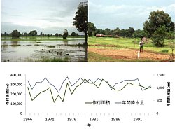
(1) The history of agricultural production and damages will be obtained
through interviews with local farmers and the analysis of agricultural
statistics.
(2) The relation between observed precipitation data and information about
agricultural activities obtained through (1) will be analyzed.
(3) Meteorological mechanisms that created local agricultural damages will
be clarified through an analysis of relations between the reanalysis data
and local observed precipitation data.
- Purpose of Joint Research
-
The purpose of this research project is to evaluate relations between meso-synoptic
scale meteorological mechanisms and local climate disasters that severely
affected agricultural production and farmers’ livelihoods in the Southeast
Asia over the last five decades through the integration of reanalysis meteorological
data (NCEP/NCAR, JRA25, etc.), observed local meteorological data, agricultural
statistics and information obtained through interviews to local people.
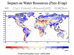
- As reanalysis products and climate projection datasets under global warming
scenarios have a similar data structure and time-spatial resolution, accumulation
of case studies about the relation between reanalysis data and phenomena
on the ground surface would forman important base for assessments of impacts
of climate changes in the future. While there have been a number of studies
conducted on the relations between reanalysis products and local hydrological
observations, studies on relations between reanalysis products and local
human activities are still rare.
- A collection of cases of relation between four elements: “meso-synoptic
circulation based on reanalysis products”, “local weather conditions based
on observations”, “agricultural damages caused by meteorological disaster”
and “adaptation of local people” will be published as a final report.
- Outline of Result
- Reliability of reanalysis data covering Southeast Asia was examined. Seasonal patterns of observed rainfall on the ground were fairly represented by reanalysis data. Influences of El Nino and La Niña were clearly seen in the local climate system in Indochina region.
Resolution of reanalysis data (a few hundred kilometers) was found too coarse to make direct comparison to agricultural activities on the ground. A new downscale method of reanalysis data with use meso-scale climate and hydrological datasets needs to be implemented.
ALOS L-band SAR image data (PALSAR) was found useful as meso-scale hydrological data which indicate soil water condition. Multi-temporal images of PALSAR can be effectively used to classify different hydrological conditions and types of paddy fields in Indochina region.
▲Top of This Page
|