Joint Research(Type Ⅱ)
Development of Web-GIS Framework for Soil Mapping and Modeling of Soil
Dynamics for Sustainable Resource Management
Project Leader: RAGHAVAN, Venkatesh, Graduate School for Creative Cities,
Osaka City University
(Term:2011 - 2012)
- Joint Seminars in 2011Fiscal Year
- Outline of Joint Research
- Soil erosion caused by deforestation and farming activities can change
soil significantly within a short-term period, particularly in mountainous
areas of Southeast Asia with a heavy monsoon climate. It will be of great
help for decision makers if they can understand soil changes and their
dynamics both in time and space in the case of land use planning and water
resource management. This research is focused on developing a framework
for managing and sharing geospatial, providing geo processing functionality
to derive up-to-date information from Remote Sensing data for soil mapping,
and execute spatial modeling algorithms to detect changes in soil dynamics.
From the end users point-of-view, this system is an online framework, in
which users can drive the system and produce a high quality soil map for
a specific site by following a systematic geospatial processing workflow
and feeding the system with the datasets that are acquired at present or
the parameters that they are familiar with based on local knowledge.
- Purpose of Joint Research
-
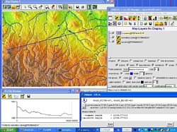
The proposed system will consists of three parts. (1) The spatial databases
that includes three categories – basic data, remote sensing data and in-situ
measurements. (2) A Geo processing engine to provide online image processing
capabilities for parameterization of environmental factors related to soil
change using remote sensing datasets, for example, detecting spatial and
temporal variations in vegetation indices that have been found to be linked
to prevailing climate, ecosystem, terrain and physical soil properties,
estimating ground components (end members) through sub-pixel analysis with
spectral mixture model, and mapping land cover through various image classifiers.
(3) GIS is used to integrate geospatial database, information derived from
remote sensing and in-situ measurements for mapping soil dynamics using
fuzzy logic based on the relationship between soil attributes, geomorphological
and environmental conditions. The system will be tested with available
geospatial data for Oudom area of Northern Laos, Luanping area of China
and parts of the Red River basin in Vietnam. The SWAT (Soil and Water Assessment
Tool) model will be used to predict the impact of land management practices
on water, sediment & agricultural chemical yields in the above target
areas.
- Outline of Result
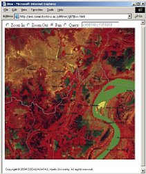
- The 2011 works focused on exploring appropriate soil mapping methodologies that enable to make fast high-quality soil map series using remote sensing and GIS with less field survey works in developing countries.
We proposed a fuzzy soil inference model for soil prediction in a mountainous basin based on stratified strategy, using topographic attributes from terrain analysis of GIS, land cover attributes derived from remote sensing, and a small number of sample points collected in field work. The attributes used to predict soil depth are called predictors or environmental variables. Among them, two categorical attribute maps, landform and land cover, are first intersected to produce basic soil mapping units that are characterized with different soil formative environment. Other maps with continuous attribute values, i.e. wetness index, are then applied for predicting spatial distribution of soil properties within each unit with the fuzzy soil inference model.
To increase the accuracy of prediction in a rocky upland area, a new predictor, surface soil-rock ratio, is introduced to identify the fractions of bare soil and rock area in land surface by sub-pixel analysis of remote sensing images. Furthermore, principal component analysis are used to convert environmental variables into a set of values of uncorrelated variables before applying soil inference as some variables are variants on similar quantities and highly correlated. Thus, it avoids the effects of correlations among predictors on soil prediction.
The method for modeling soil properties takes full advantages of free Japanese ASTER GDEMs and the opening of HJ-A remote sensing images, and made it possible about a less expensive works of collection data samples in field work by combining the knowledge of local soil scientists with GIS techniques under fuzzy logic for soil mapping. This soil mapping approach has been demonstrated in Hushiha watershed, Chaohe river, Northern China.
▲Top of This Page
|