共同研究 (タイプⅡ:拠点集中型)
「持続可能な資源管理のための土壌マッピングと土壌ダイナミクスモデリングに関するWeb-GISシステムの開発」
研究代表者: Venkatesh Raghavan(大阪市立大学・大学院創造都市研究科)
(実施期間:平成23年度~平成24年度)
- 研究概要
-
東南アジアにおける森林伐採や農業活動に起因する土壌浸食は、モンスーン気候の山間部を中心にごく短い周期で土地の性質を大幅に変化させている。この問題の解決には、土地利用計画と水資源管理の視点から土壌の変化を時間と空間的に理解することが重要になってくる。本研究では、GISとリモートセンシング技術を用いた時空間データベース設計を専門とするCollege
of Resources and Environmental Sciences, Graduate University of Chinese
Academy of Sciences(中国)のSONG Xianfeng氏(准教授)を2012年度に招へいし、土壌マッピングと土壌ダイナミクスモデリングに関するWeb-GISシステムの開発を行う。
- 研究目的・意義・期待される効果
-
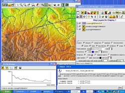
土壌の性質は地質学、景観、土地利用、土地被覆、水文学や農業などさまざまな地理的な環境パラメータが関連している。土壌の専門家はGISやリモートセンシング技術、現地調査データを用いて土壌の時間的かつ空間的なダイナミクスを考えている。しかしながら、現在の土壌がどのように変遷されてきたかを示す土壌変遷マップをどのように作成してきたのかが明確でないため、これらのシステムの共有化やオープン化を考慮することは極めて重要であると考える。本研究では、リモートセンシングデータを用いて検出した最新の土壌情報を土壌マッピングシステムとして可視化し、土壌のダイナミクスを時空間的に共有するフレームワークを開発することである。
本研究で提案するプラットフォームは、国際標準として使用されているオープンソース地理空間ソフトウェアを使用するためさまざまな分野への応用利用が可能である。本研究で構築する具体的なシステムは次の2点である。(1)地質データやDEMなどの地形データ、リモートセンシングを用いた土地利用の変遷データ、現地計測データ等を含めた基盤データの空間データベース設計、(2)リモートセンシングデータを用いた画像処理から土壌の変遷や土地利用を分析、解析するための地理空間データ処理システムの構築。
招へいを希望しているSONG Xianfeng氏は、Web-GISと空間データベースを研究している国際的な第1人者である。とくに地理情報解析メタデータサーチエンジン開発・応用などの業績を持つ。Web-GISを共同研究することにより、より高度な空間情報共有および解析のシステム開発が可能となる。
- 研究成果概要
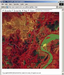
- The 2011 works focused on exploring appropriate soil mapping methodologies that enable to make fast high-quality soil map series using remote sensing and GIS with less field survey works in developing countries.
We proposed a fuzzy soil inference model for soil prediction in a mountainous basin based on stratified strategy, using topographic attributes from terrain analysis of GIS, land cover attributes derived from remote sensing, and a small number of sample points collected in field work. The attributes used to predict soil depth are called predictors or environmental variables. Among them, two categorical attribute maps, landform and land cover, are first intersected to produce basic soil mapping units that are characterized with different soil formative environment. Other maps with continuous attribute values, i.e. wetness index, are then applied for predicting spatial distribution of soil properties within each unit with the fuzzy soil inference model.
To increase the accuracy of prediction in a rocky upland area, a new predictor, surface soil-rock ratio, is introduced to identify the fractions of bare soil and rock area in land surface by sub-pixel analysis of remote sensing images. Furthermore, principal component analysis are used to convert environmental variables into a set of values of uncorrelated variables before applying soil inference as some variables are variants on similar quantities and highly correlated. Thus, it avoids the effects of correlations among predictors on soil prediction.
The method for modeling soil properties takes full advantages of free Japanese ASTER GDEMs and the opening of HJ-A remote sensing images, and made it possible about a less expensive works of collection data samples in field work by combining the knowledge of local soil scientists with GIS techniques under fuzzy logic for soil mapping. This soil mapping approach has been demonstrated in Hushiha watershed, Chaohe river, Northern China.
▲ページトップ
|