Project Leader:TSUMURA, Hiroomi (Faculty of Culture and Information Science, Doshisha University),
Collaborators: SHIBAYAMA, Mamoru (Center for Integrated Area Studies, Kyoto University)
KOBAYASHI,Satoru(Center for Southeast Asian Studies, Kyoto University)
TASHIRO, Akiko (Department of Planning and Coordination
Nara National Research Institute for Cultural Properties)
TAKATA, Yuuichi(Center for Knowledge Science in Cultural Heritage, Doshisha University)
Term:2012-2013
Outline of Research:
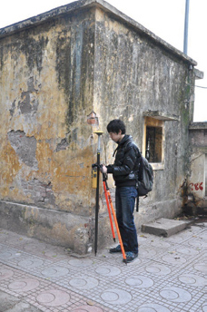
Base point measurement with DGPS
The purpose of this research is to reconstruct the historical cultural landscape of Hanoi by using spatio-temporal informatics which are based on GIS. Specifically, it will carry out the following surveillance study.
- Digitization of historical map materials
- GIS archive of digitalized spatial and historical data
- Quantification of time series changes of city structure
- Restoration of history and culture based on a model evaluation
Description:
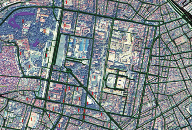
GIS archive data of Hanoi
The Imperial Citadel of Thang Long – Hanoi, can be approached through many historical records such as maps, texts and drawings. However, it is not easy to verify the mutual relations between these sources of information as they are archived in separate places and formats. In this research, we aim to unify them at the dimension of information through spatio-temporal informatics and by using GIS. Until now the unification of excavation survey data and information has not been carried out. The purpose of this research is to reconstruct a historical cultural landscape of Hanoi through these methods. One additional advantage of this research is to create an information system in Kyoto University. where we will prepare a data server, input all data and make it accessible to the public. This research aims at the the following results: To integrate intelligence infrastructure on Hanoi. Open promotion through WebGIS technology. Offer quantitive understanding about changes to the historical environment of Thang Long. To consider the cultural background about Thang Long. A measurement study that evaluates the city structure.
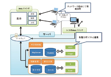
Computer system model